Vantor offers up-to-date imagery with WorldView 3D
SAN FRANCISCO – Vantor, the company previously known as Maxar Intelligence, unveiled WorldView 3D July 1, to provide customers with updated and high-definition imagery.
“WorldView 3D is driving towards currency,” Peter Wilczynski, Vantor chief product officer, told SpaceNews. “At the click of a button, you see what the world looks like in 3D.”
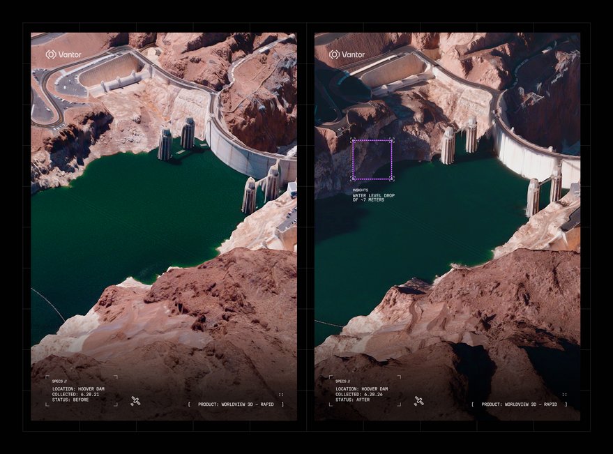
The WorldView 3D line includes two products. WorldView 3D Rapid allows customers to task satellites and receive updated 3D maps with a resolution of 50-centimeters within 24 hours. For 3D maps at 15-centimeter resolution produced from satellite imagery, customers can opt for WorldView 3D High Definition (HD).
WorldView 3D HD promises 3-meter accuracy in three dimensions, compared with 4 meters for WorldView 3D Rapid.
“One of the big bets we have as a company is that AI models, which are not natively three dimensional, will need to be grounded into that three-dimensional world for artificial intelligence analytics workflows and robotics workflows,” Wilczynski said.

Roots in Vricon
Vantor’s focus on 3D dates back to 2020, when the company took ownership of Vricon, a specialist in 3D geospatial products and analytics formed by Vantor predecessor DigitalGlobe and Swedish defense company Saab. While Vricon focused primarily on creating 3D maps with aerial imagery, Vantor has applied similar techniques to its extensive satellite-imagery archive.
WorldView 3D is made possible by “breakthroughs” in Vantor’s world model reconstruction algorithm, Wilczynski said. “We look at the 3D that we’ve built historically and use that to build the new data much more quickly.”
Vantor also can rapidly update imagery thanks to its six WorldView Legion satellites launched in 2024 and 2025, Wilczynski said.
With WorldView 3D Rapid, intelligence analysts, commanders and tactical operators planning missions or identifying changes on the ground will gain an up-to-date view without aircraft or drones, according to the new release. Additional applications include disaster response, infrastructure monitoring and autonomous navigation.
Another Vantor product that benefits from WorldView 3D is Raptor, a terrain-based positioning system for drones in GPS-denied environments. “You can collect data, process it, upload it to the drone, and now the drone is able to fly, even if the environment is changing a ton,” Wilczynski said.

Space-based mapping
WorldView 3D HD is designed for mapping organizations that have relied historically on aerial imagery. “We anticipate a lot of those markets to be unlocked,” Wilczynski said.
Vantor has mapped more than 100 million square kilometers of the world in 3D with an accuracy of 3 meters, according to the news release. “WorldView 3D extends that foundation using proprietary fusion and processing techniques that can update 3D terrain with a small number of new images — and for the rapid delivery capability, a single satellite pass is enough.”